Thompson, Pennsylvania
Thompson, Pennsylvania | |
|---|---|
 Ice cream store in the old railroad station | |
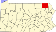
 Location of Thompson in Susquehanna County, Pennsylvania. | |
| Coordinates: 41°51′44″N 75°30′57″W / 41.86222°N 75.51583°W | |
| Country | United States |
| State | Pennsylvania |
| County | Susquehanna |
| Incorporated | 1876 |
| Government | |
| • Mayor | Jeffry Sheldon[1] |
| Area | |
| • Total | 0.51 sq mi (1.33 km2) |
| • Land | 0.51 sq mi (1.33 km2) |
| • Water | 0.00 sq mi (0.00 km2) |
| Population | |
| • Total | 255 |
| • Estimate (2021)[3] | 254 |
| • Density | 525.39/sq mi (202.83/km2) |
| Time zone | UTC-5 (Eastern (EST)) |
| • Summer (DST) | UTC-4 (EDT) |
| Zip code | 18465 |
| Area code | 570 |
| FIPS code | 42-76496 |
Thompson is a borough in Susquehanna County, Pennsylvania, United States. The population was 255 at the 2020 census.[3]
Geography
[edit]Thompson is located at 41°51′44″N 75°30′57″W / 41.86222°N 75.51583°W (41.862354, -75.515864).[4]
According to the United States Census Bureau, the borough has a total area of 0.5 square miles (1.3 km2), all land.
History
[edit]Thompson Borough was incorporated on August 15, 1876 from part of Thompson Township. Both were named after Susquehanna County associate judge William Thompson.[5]
The Spencer Milling Company gristmill was built on Jackson Street by G. Fenton Spencer in 1870.[6]
Demographics
[edit]| Census | Pop. | Note | %± |
|---|---|---|---|
| 1880 | 249 | — | |
| 1890 | 302 | 21.3% | |
| 1900 | 309 | 2.3% | |
| 1910 | 322 | 4.2% | |
| 1920 | 295 | −8.4% | |
| 1930 | 321 | 8.8% | |
| 1940 | 339 | 5.6% | |
| 1950 | 320 | −5.6% | |
| 1960 | 286 | −10.6% | |
| 1970 | 307 | 7.3% | |
| 1980 | 303 | −1.3% | |
| 1990 | 291 | −4.0% | |
| 2000 | 299 | 2.7% | |
| 2010 | 299 | 0.0% | |
| 2020 | 255 | −14.7% | |
| 2021 (est.) | 254 | [3] | −0.4% |
| Sources:[7][8][9] | |||
At the 2010 census there were 299 people, 126 households, and 78 families residing in the borough. The population density was 598 inhabitants per square mile (231/km2). There were 163 housing units at an average density of 326 per square mile (126/km2). The racial makeup of the borough was 98.7% White, 0.3% African American, and 1% from two or more races. Hispanic or Latino of any race were 0.7%.[10]

Of the 126 households, 26.2% had children under the age of 18 living with them, 42.1% were married couples living together, 14.3% had a female householder with no husband present, and 38.1% were non-families. 27.8% of households were one person, and 11.1% were one person aged 65 or older. The average household size was 2.37 and the average family size was 2.90.
In the borough the population was spread out, with 23.1% under the age of 18, 60.8% from 18 to 64, and 16.1% 65 or older. The median age was 42 years.
The median household income was $31,875 and the median family income was $31,250. Males had a median income of $30,000 versus $19,688 for females. The per capita income for the borough was $14,883. About 20.7% of families and 25.1% of the population were below the poverty line, including 36.3% of those under the age of eighteen and 35.7% of those 65 or over.

References
[edit]- ^ "Municipalities". Montrose, PA: Susquehanna County Courthouse. Retrieved 28 December 2020.
- ^ "2019 U.S. Gazetteer Files". United States Census Bureau. Retrieved July 28, 2020.
- ^ a b c d Bureau, US Census. "City and Town Population Totals: 2020—2021". Census.gov. US Census Bureau. Retrieved August 5, 2022.
{{cite web}}:|last1=has generic name (help) - ^ "US Gazetteer files: 2010, 2000, and 1990". United States Census Bureau. 2011-02-12. Retrieved 2011-04-23.
- ^ "Thompson Township". Susquehanna County Historical Society. Retrieved 9 March 2013.
- ^ "Spencer Milling Company". Pennsylvania Historical and Museum Commission. Retrieved 11 March 2016.
- ^ "Census of Population and Housing". U.S. Census Bureau. Retrieved 11 December 2013.
- ^ "U.S. Census website". United States Census Bureau. Retrieved 2008-01-31.
- ^ "Incorporated Places and Minor Civil Divisions Datasets: Subcounty Resident Population Estimates: April 1, 2010 to July 1, 2012". Population Estimates. U.S. Census Bureau. Archived from the original on 11 June 2013. Retrieved 11 December 2013.
- ^ "U.S. Census website". United States Census Bureau. Retrieved 2011-05-14.


